
YAY...Alan and I added a map of our travels -- with help from our friend, Margery, who forwarded a link that gave step-by-step instructions...thanks, Margery.
What's in Mitchell, South Dakota, you ask? MOSQUITOES and GNATS -- cannot go outside without being attacked, except on the days when it is really windy. Arriving in South Dakota last week, we assumed the wind constantly blowing was normal; however, we had rain Saturday night and afterward, the wind completely stopped.
Alan killed this mosquito and to show how big it was, he laid it next to a dime...he must not have enough to do, uh?

On Wednesday, June 30, we set out to see what we could find in Mitchell. First, we stopped at Pirogues (Pronounced Pi-Roes) BBQ for lunch. After our experience with South Carolina BBQ, we were really interested to see what South Dakota BBQ was like.

Pirogues not only serves Texas BBQ, but also feast Louisiana Seafood. Of course with the oil problem in the Gulf, we aren't too sure where they are actually getting their seafood. The smoked meats of brisket, pulled pork, ribs, sausage and chicken are all sold by the pound, plus as sandwiches. They have a variety of help-yourself sides, which sell for $1.69 ea.


I'm happy to report it was very good. I selected a homemade spicy BBQ sauce for my pulled pork and Alan chose a sweet sauce for his pork sandwich.
Mitchell is very proud of the fact it is home to the world's only Corn Palace.

The first Corn Palace was built in 1892, three years after South Dakota became a state. Early settlers displayed the agricultural bounty on the building's exterior to prove the fertility of the region's soil. The building is famous for the huge, colorful murals on its sides, which are redesigned each year. The 2010 theme is "Through the Ages," depicting modes of transportation and travel. Much of the work is done by hand and is a detailed process. In June, the border trim of rye and sourdock is removed from the building.

The new sourdock and rye is cut and tied into bundles, which is what these young men were doing the day we were there.

The City of Mitchell hires local youth during the summer to work at the Corn Palace.
After the old murals are removed, sketches created by local artists are transferred to roofing paper and nailed to the mural panels. Each color of corn and the area it covers is indicated on the drawing. I bet you didn't know there were 12 different colors of corn. These 12 shades of colored corn are planted in separate fields to ensure color purity and are hand-picked. We were stunned to learn there are 65,000 acres of corn planted each year just for the Corn Palace. Each ear of corn is sawed in half, shaped and trimmed to fit their designated place, then nailed into place. Approximately 275,000 ears of corn are used to redecorate the murals each year.
The Corn Palace also serves as a gathering place. Every harvest season for over a 100 years, people have come together for entertainment. In the beginning, there were marching bands like Sousa, followed through the years by a mix of top quality entertainment. It also is a place for proms, dances, banquets and sporting events. In fact, USA Today has named the Corn Palace as one of the Top 10 places to play high school basketball games and dubbed it the Boston Gardens of the Midwest.
During the summer when the tourist season is at its highest, the Palace floor is transformed into a sales room with a sundry of items to choose from, even popcorn from South Dakota corn.

The murals on the inside never change and were created by the famed American Indian Oscar Howe and depict various activities relevant to the settling of the land now known as South Dakota. Admission is free and is open year-round.
Our next stop was the Dakota Discovery Museum. We were not allowed to take pictures on the inside, but the museum houses three homes and three ways of life in early South Dakota: a buffalo hide tipi, a replica of a claim shack and a sheep wagon, where author Archer Gilfillan lived between 1915 and 1933 and wrote his book, "Sheep: Life on the South Dakota Range." The museum also includes art galleries, featuring artists like Oscar Howe, Gutzon Borglum, among others.
There were several buildings on display outside as part of the Museum. One is the Farwell Church, built in 1908 and had its closing service in 1986.


Also on display is the one-room Sheldon School, constructed in 1884.


On the wall was a list of rules for teachers, including such things as: "...fill lamps, clean chimneys, trim wicks each day. Men may take one evening each week for courting purposes or two evenings a week if they attend church regularly. After ten hours in school, the teacher should spend the remaining time reading the Bible or other good books."
The Dakota Discovery Museum is located across the street from Dakota Wesleyan University, as well as the George and Eleanor McGovern Library, Wesleyan's most famous graduates.
Our last stop of the day was the Prehistoric Indian Village. More than 1000 years ago, bands of native farmers and hunters used the land along Firesteel Creek as farming ground, where they raised corn, squash, tobacco, etc. The women tended the crops while the men hunted and fished along the creek. A Dakota Wesleyan University student discovered the first signs of ancient human activity around the site in 1910. The history of the site has been preserved and the Indian Village was declared a National Historic Landmark. These Native Americans lived in lodges, where 12-20 family members lived together. The Prehistoric Indian Village depicts what those lodges perhaps looked like, based on research and archeological findings. Each lodge was roughly 20' by 35' and the walls were made from a mixture of clay, grass and branches. The "bed" in the center of the lodge was reserved for the respected person in the lodge.


Bison were plentiful in this region and were used for food, as well as a resource for warmth in cold weather and for constructing various tools.
Today the area looks much different. The creek was damned and Mitchell Lake was made, with modern homes built around it.

We made our way to the Thomsen Center Archeodome -- located adjacent to the Indian Village. The Center is a 10,000 square foot building that encloses two full lodges. This is where visitors can actually see archeological work being conducted.

The building includes a laboratory, classroom and video conferencing studio and is open to the public.
It was interesting to watch the young students earnestly at work, searching for bones and other artifacts. We learned that a team of students from the University of Exeter in England travel to Mitchell each summer to work during the month of July.


Alan actually wanted to jump in and help out, but unfortunately, we were only allowed to watch.
On Thursday morning, July 1, we drove two plus hours west on I-90 to Pierre (pronounced Peer), the capitol of South Dakota. I have been pronouncing Pierre wrong for a very long time. We stopped at a Rest Area with a scenic, historical view overlooking the Missouri River.

The United States gained South Dakota as part of the Louisiana Purchase in 1803, which sparked an interest in expansion into the Northwest Region. The United States did not know exactly what it was buying and France was unsure of how much land it was selling. President Jefferson asked Congress for $2500 for an expedition to explore the Northwest, its resources, inhabitants, etc. Thus, the Lewis and Clark Expedition, we all remember from high school history, came about. Jefferson selected Army Captain Meriwether Lewis to lead the expedition. Lewis selected William Clark as his partner. In September 1804, continuous rain had soaked their gear as they traveled up the Missouri River. Here in warm and delightful weather, they rested, dried their equipment and repacked their boats.
As we continued westward on I-90, we began to climb and the terrain began to change. We began to see rolling hills.
 Unlike most state capitols, the interstate does not go around Pierre...you must exit on to Hwy 83 north for approximately 35 miles to reach Pierre. Here we saw more pronounced hills.

South Dakota is named after the Lakota and Dakota Sioux Indian tribes. Pierre is the capitol, but Sioux Falls is South Dakota's largest city. I admit we have not been in very many state capitol buildings, but this one was exceptionally beautiful we thought from the outside...

...through the doors where we were greeted by a volunteer who presented us with our own private tour of the capitol building.


We learned even more about our new home state -- more than you have time to read or I have time to report.
However, South Dakota's capitol building is beautiful. If you ever have the opportunity to see it, please do. Our guide was pretty emphatic that South Dakota is definitely a red state. We are proud to be Americans, as well as South Dakotans.
As we prepare to leave South Dakota and return to Illinois to hopefully complete our AC repair, we pray you will join us again to see what we find on our journey.
May God continue to bless our voyage and our family and friends wherever they are.

The United States gained South Dakota as part of the Louisiana Purchase in 1803, which sparked an interest in expansion into the Northwest Region. The United States did not know exactly what it was buying and France was unsure of how much land it was selling. President Jefferson asked Congress for $2500 for an expedition to explore the Northwest, its resources, inhabitants, etc. Thus, the Lewis and Clark Expedition, we all remember from high school history, came about. Jefferson selected Army Captain Meriwether Lewis to lead the expedition. Lewis selected William Clark as his partner. In September 1804, continuous rain had soaked their gear as they traveled up the Missouri River. Here in warm and delightful weather, they rested, dried their equipment and repacked their boats.
As we continued westward on I-90, we began to climb and the terrain began to change. We began to see rolling hills.


South Dakota is named after the Lakota and Dakota Sioux Indian tribes. Pierre is the capitol, but Sioux Falls is South Dakota's largest city. I admit we have not been in very many state capitol buildings, but this one was exceptionally beautiful we thought from the outside...

...through the doors where we were greeted by a volunteer who presented us with our own private tour of the capitol building.


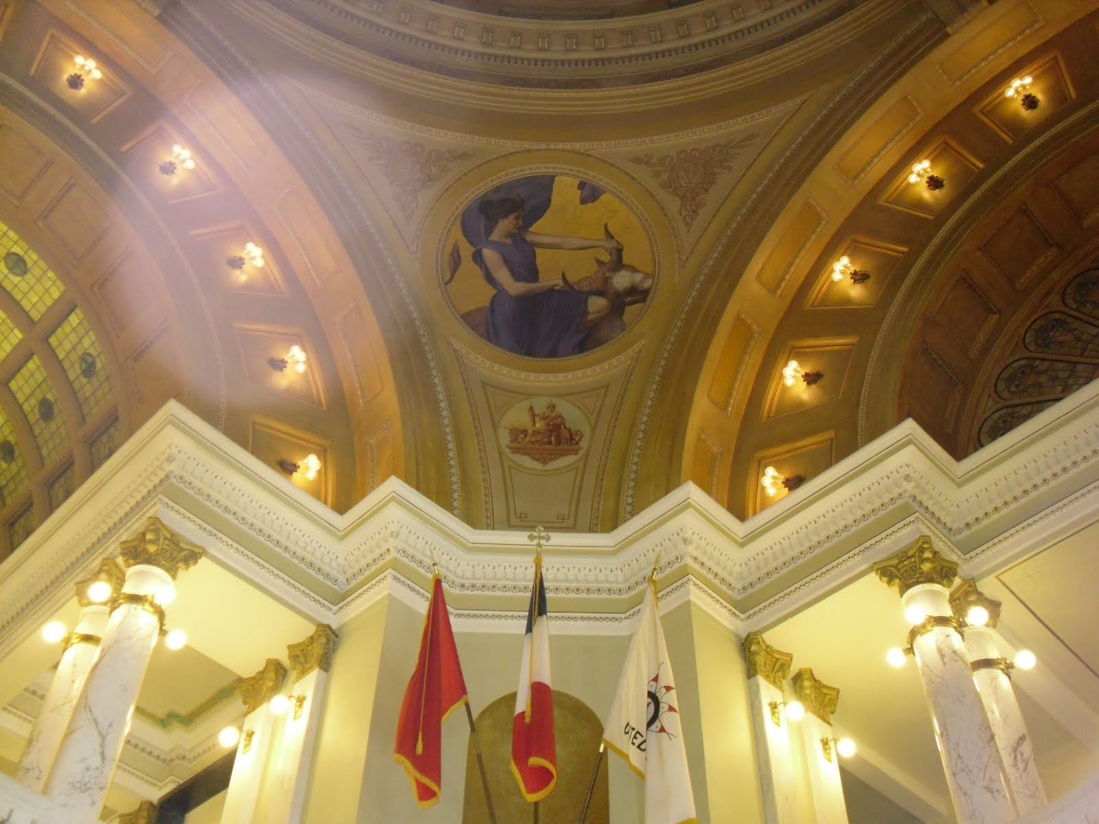
The distance from the Rotunda floor to the top center black circle of the dome is 96 feet. From the top of the Rotunda to the ball on top of the copper outer dome is an additional 65 feet. Greek, Roman and Celtic architecture are the primary symbolic design features used in the construction of the South Dakota Capitol.
In each corner of the Rotunda Dome is a large Circular mural, each portraying a Greek goddess: Venus with Cupid, Ceres, Minerva and Europa with Zeus (the bull). The 1910 murals by Edward Simmons were painted to represent the major interests in South Dakota: Love of Family, Love of State -- Agriculture, Wisdom, Industry and Mining -- and Livestock.


We learned even more about our new home state -- more than you have time to read or I have time to report.
However, South Dakota's capitol building is beautiful. If you ever have the opportunity to see it, please do. Our guide was pretty emphatic that South Dakota is definitely a red state. We are proud to be Americans, as well as South Dakotans.
As we prepare to leave South Dakota and return to Illinois to hopefully complete our AC repair, we pray you will join us again to see what we find on our journey.
May God continue to bless our voyage and our family and friends wherever they are.
No comments:
Post a Comment